
Travel in times

Travelintimes.org is a historic online journey planner, created at the University of Cambridge, that allows users to plan journeys around England and Wales at three dates in time, c.1680, c.1830 and in 1911. The website allows users to explore the nature of travel in the past and how it improved over the period 1670 to 1911 based on the latest historical research. Travelintimes.org builds upon the results of series of research projects at the University of Cambridge. Read more about the research project…
At the moment the journey planer is still in development phase and only allows three choices:
The journey planner allows you to plan journeys between any two points on the map and will show you the route taken, the location of overnight stops (if any) and give the cost of the journey, broken down into various elements) first in the currency and prices of the day, second in terms of how many hours of unskilled adult male labour would be required to pay for the journey, and third converts that into modern money by valuing the hours of contemporary unskilled labour at the current minimum wage.
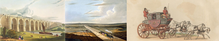
These dates have been chosen to illustrate key aspects of the development of transport systems. In 1680 the improvement in the road network brought about by Turnpike Trusts (which charged tolls) had hardly begun and the modern era of canal construction had not yet begun. By 1830 the turnpike network was at its peak covering around 20,000 miles and the canal network was almost at its peak. The first steam-powered passenger railway in the world, the Liverpool to Manchester line opened in 1830 but by 1911 the rail network was at its peak while the humble bicycle spread rapidly from the 1890s.
In 1680 the standard of roads was very poor and many roads were impassable to wheeled vehicles for much or all of the year which made riding on horseback (side-saddle for women in this period) the only alternative to walking for most long-distance passenger journeys. Read more about travelling conditions in 1680…
By 1830 there was a very extensive network of turnpike (toll roads) capable of taking wheeled traffic even at night. In consequence there was a highly developed network of stage coach routes which allowed those who could afford it to travel around the country radically faster than had been possible in 1680 and in much more comfort. Read more about travelling conditions in 1830…
By 1911 a dense railway network meant that travel around the country was very much faster than in 1830 as well as being more comfortable, safer and much cheaper. Third class fares brought railway travel within the budgets of large sections of the working class. The invention and spread of the bicycle had also greatly democratised access to travel while the rich could travel by car. Read more about travelling conditions in 1911...
We will be adding other kinds of journeys, including freight journeys to the site soon. Read more…
The data which underlies the website was created on a sequence of research projects in the department of Geography and the Faculty of History at the University of Cambridge since 2006. These projects were funded by the Economic and Social Research Council, the Leverhulme Trust, the British Academy and the Isaac Newton Trust (Cambridge).
A number of projects were led by Dr Leigh Shaw-Taylor and Professor Sir E.A. Wrigley between 2003 and 2012, focussed on reconstructing the occupational structure of England and Wales between the late middle ages and the outbreak of the First World. We soon became interested in looking at the role of changes in transport infrastructure in causing changes in population geography and local occupational structures. From 2006 Dr Max Satchell worked on the project which then underwent a ‘spatial turn.’ With colleagues in Spain (led by Professor Jordi Marti-Henneberg) we created digital maps of the railway network and stations for every year from 1825 to 2010 from Michael Cobb's definitive atlas The Railways of Great Britain. Max Satchell then created maps of the navigable rivers and canals of England and Wales for every year from 1600 to 1947. In 2012 we began a new Leverhulme Trust funded project with Professor Dan Bogart (University of California at Irvine) who secured additional funding from the US National Science Foundation. Dr Xuesheng You, Ms Annette MacKenzie, Dr Eduard Alvarez and Dr Alan Rosevear joined the team. Satchell and Rosevear mapped the emerging turnpike (toll) roads of England and Wales for every year from 1660 to the final demise of the system in 1897. Satchell, Alvarez and others created maps of the ports and coastal shipping routes.
Finally, Alvarez connected all the networks together to produce a ‘multi-modal’ version of all the networks at three benchmark dates c.1680, c.1830 and 1911. This final step allows use to use network analysis software to analyse the characteristics of the network and model journeys around it.
We secured additional funding from the Higher Education Impact Fund to create an online journey planner and were fortunate to secure the services of Mr Martin Lucas-Smith (journey planner expert from CycleStreets) to develop the software.
Read more on the transport research project…
Read more on the occupational structure project…
The Online Historical Atlas of Transport, Urbanization and Economic Development in England and Wales c.1680-1911
Editors: L. Shaw-Taylor, D. Bogart and A.E.M. Satchell
Chapter 1 Navigable waterways and the economy of England and Wales 1600-1835
Max Satchell (2017)
Chapter 2 The Turnpike Roads of England and Wales
Dan Bogart (2017)
Chapter 3 The development of the railway network in Britain 1825-1911
Dan Bogart, Leigh Shaw-Taylor and Xuesheng You (2018)
In the near future we hope to be able to extend the functionality of the system in two ways.
Firstly, to give users a range of options for passenger journeys at each date, optimising on cost (walking and sleeping in barns or under hedges) (ii) on speed (horseback in 1680, stagecoach in 1830, railway in 1911 or comfort/convenience (which in 1911 would mean a motor-car journey).
Secondly, we will add the option to plan freight journeys around the country, initially using coal as an example of a commodity with a low value to weight ratio and woollen cloth as an example of high value to weight commodity. The output from the journey planner will show the route, the time taken, the cost and show how the cost of transport influenced the cost to the consumer.
We hope the website will be of interest to the general public but also that it will be widely used for teaching purposes in both history and geography in schools and colleges.
Between the late seventeenth and early nineteenth centuries England underwent both massive urbanisation and a radical transformation of the urban hierarchy not paralleled in any other European country. Over the same period the country's transport infrastructure was transformed, by river improvements, by turnpike road construction, by the creation of a canal network, the railways and the advent of steam-powered iron and steel hulled ships. These two developments were closely related to a third, the diffusion of new productive technologies.
These videos show the evolution of turnpike roads, railways, and navigable waterways over the centuries.
Evolution of turnpike roads from 1663 to 1896:
Evolution of railways from 1811 to 2001:
Evolution of navigable waterways from 1600 to 1911:
Some contemporary diarists, auto-biographers and authors of travel journals recorded their journeys in considerable detail. Such accounts are invaluable in allowing us to understand the nature of travel in the period. Hundreds and probably thousands of such accounts survive between 1660 and 1914.
Narrative descriptions of specific journeys from a small selection of surviving accounts have been written to accompany the historic journey planner to give a flavour of the nature of travel in the period. Accounts by foreigners are often particularly valuable because they describe and explain things that a 'local' might take for granted was known to the reader and hence not both to describe.
| William Schellinks | A journey from Hellovoetsluijs Netherlands to Dover via Harwich and Gravesend in 1661. |
| William Stout | A Lancaster shopkeeper travels to London and back to stock his shop in 1688, 1689 and 1690. |
| James Woodforde | Oxford undergraduate and later Norfolk Parson. A journey on horseback in 1761. |
| Karl Moritz | A German visitor to England in 1782. He describes both walking around England and travelling by stage-coach. |
| Charles Hatchett | A scientist travels around England and Scotland by stage-coach in 1796. |
| Mary Hardy | A Norfolk businesswoman makes two visits to London in 1777 and 1800. |
| Kume Kunitake | A Japanese visitor in 1872, part of a fact-finding mission from Japan, he describes a number of train journeys. |
The value of these accounts goes well beyond the 'colour' they add to the journey planner. We are using them for the underlying research project to create datasets on a wide variety of subjects. These include:
The Travel in times website has been made possible by funding from the Higher Education Innovation Fund (HEIF 5).
The research projects which underlie the historic journey planner were funded by: the Leverhulme Trust, The National Science Foundation (US), the Economic and Social Research Council, the British Academy and the Isaac Newton Trust (Cambridge).
We would like to acknowledge the generous financial support of all these bodies.